The earth's natural resources are vital for our further development, our survival, as well as for financial and economic stability. And yet we regularly endanger nature with our own activities. To bring this process to a halt, we must act on the basis of objective data. Remote sensing is increasingly the indispensable ally in this story.
Governments, organisations (also cleantech), companies and scientists need objective data in order to make well-informed decisions. It is time to switch to a data-driven policy in Flanders, Europe and worldwide.
The power of remote sensing
Striving for a balance between our consumption and the natural resources, we must focus on assessing, planning and monitoring our socio-economic fabric to achieve this. The great technological advances in combining data and information can help us do that. VITO has been relying on the power of space technology and remote sensing for decades. The number of technologies and applications is growing rapidly, and the possibilities – for example in or combined with data fusion or artificial intelligence – are unlimited.
The future of the digital age is being shaped by platform-driven ecosystems involving multiple players worldwide. The interconnected platforms share data through machine-to-machine interfaces. The knowledge, data acquisition tools, applications and platforms – initially developed for localised use – can now be distributed worldwide.
Data acquisition and science
Due to technological and economic evolutions, we are getting more and more data from aerospace and aviation systems. Though not yet cheap, these systems are becoming more affordable for both private and public parties. Initially, only large international groups such as the UN, FAO and WHO used remote sensing data. That changed in 2017 when the European Earth observation programme Copernicus made data from a satellite constellation available free of charge (Access to Copernicus satellite data | Copernicus). Today, commercial initiatives also provide detailed data on a regular basis.
In aviation, the introduction of drone technologies has been made possible by technological progress, affordable prices and amended legislation. This also generates a lot of new data.
Unlocking sustainable strategies and products
Remote sensing facilitates innovative sustainable strategies and products. The only way we can work on solutions is through a multidisciplinary approach that utilises knowledge and additional data from platforms managed by others. Advances in computing power and data science are bringing unprecedented capacity in terms of
- data fusion: augmenting remote sensing data with data about the weather, economy, population or soil from Internet-of-Things (IoT) devices through machine-to-machine interfaces with other platforms
- data analysis with conventional techniques, artificial intelligence (AI) and deep learning (DL): following evolutions in the algorithms of major companies such as Google and Meta and integrating them as optimally as possible in our domain.
- data distribution: big data technology, web services and mobile applications provide smooth yet controlled access to data worldwide, essential for next-level applications.
Numerous relevant applications
Agriculture
Agriculture is under pressure. The urgent sustainability transition (climate change, nitrogen, water scarcity, soil depletion, food security ...), and guaranteeing and optimising productivity (seed breeding, field monitoring & management) pose major challenges. The use of satellite and aerial images is not new. But we are increasingly evolving towards truly digital agriculture with Flanders as the absolute frontrunner thanks to platforms such as WatchITgrow & MAPEO for
- monitoring, collecting and processing data
- providing relevant information to farmers (productivity, disease detection, fertilisation and irrigation), seed breeders (climate adaptation, predictive breeding) and governments (Green Deal), ...
The WatchITgrow platform, initially developed to map and monitor the agricultural area in Flanders in detail, now functions as a collaboration platform between knowledge institutions, farmers and the business community, where the algorithms are shared to enable a sustainable future.
Marine and maritime environment
It is difficult to overstate the importance of water for our planet. Monitoring and safeguarding water quality is therefore an essential component in our pursuit of sustainability. Using drone and satellite images, marine and maritime experts examine water surfaces and share the information with the government and dredging companies, for example. These types of images are also deployed in new approaches to improve logistics processes and operations, for example to map and analyse plastic pollution or flooding. Sometimes it is useful to investigate the environment in and around water. In the port of Antwerp, for instance, this is used to optimise infrastructure and detect oil leaks.
Circular economy
The evolution from a linear to a circular economy will only succeed if we review the production and use/reuse of materials and raw materials in every step. So we must learn to think in terms of stock management of materials, rather than waste management. As a technological development in digitalisation, data fusion and data analytics accelerates, remote sensing will increasingly be able to contribute by collecting data in an objective and digital way.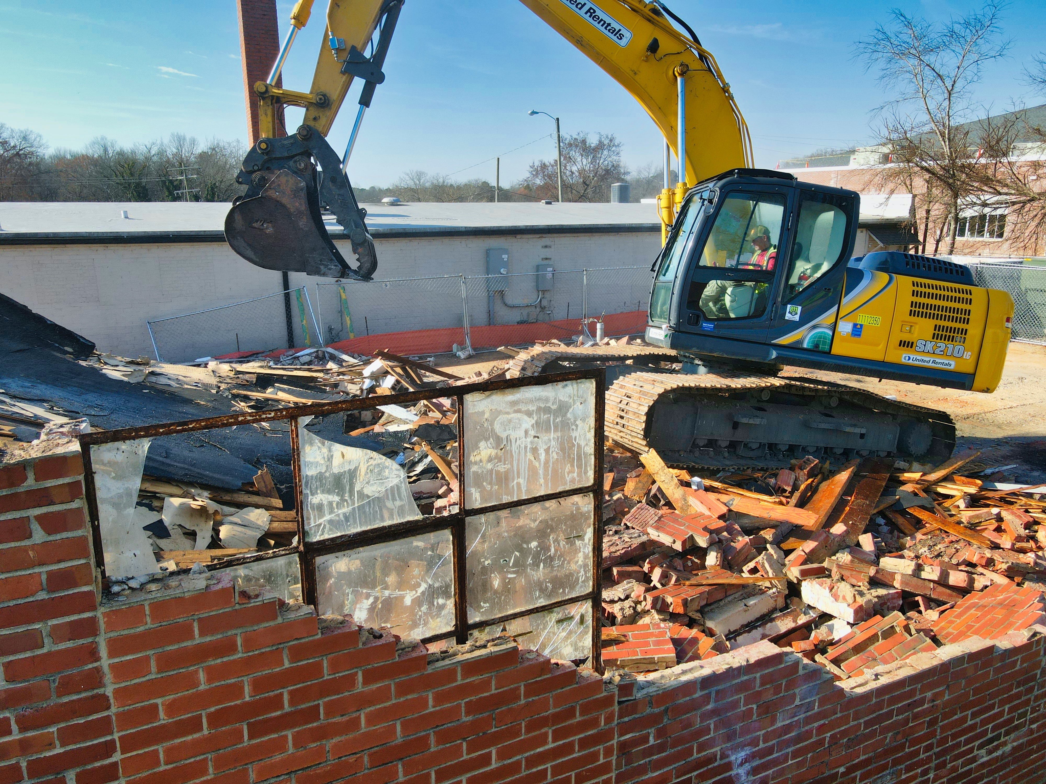
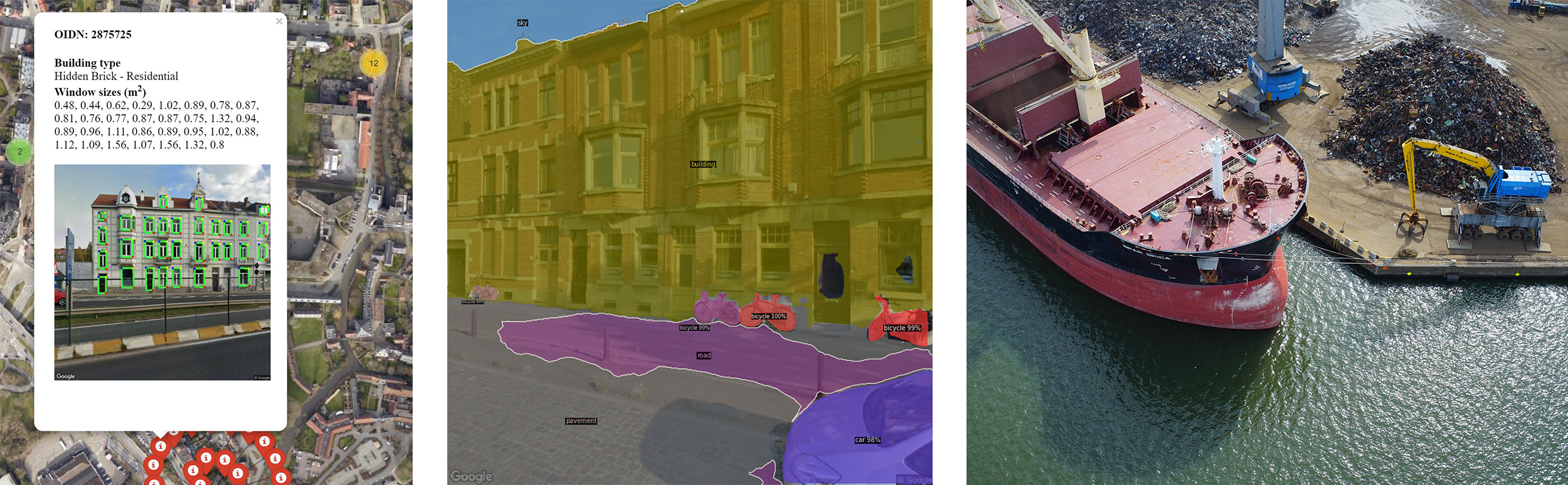
Construction is one of the sectors that consumes the most raw material. VITO's Demolition Guide project explores how we can deal with this better. This has already resulted in a proof of concept for using AI in combination with satellite images at street level to detect the building material in buildings in urban areas. This is linked to information about when these materials will be released, for example when a building is demolished, thereby facilitating circular stock management with optimisation of supporting services and storage. Naturally, this only works when buyers and distributors of recovered materials are in contact with each other.
There are many other examples where remote sensing and AI contribute to a circular economy, such as estimating the potential of solar energy or detecting asbestos. The technology is ready.
Steven Krekels
VITO Remote Sensing